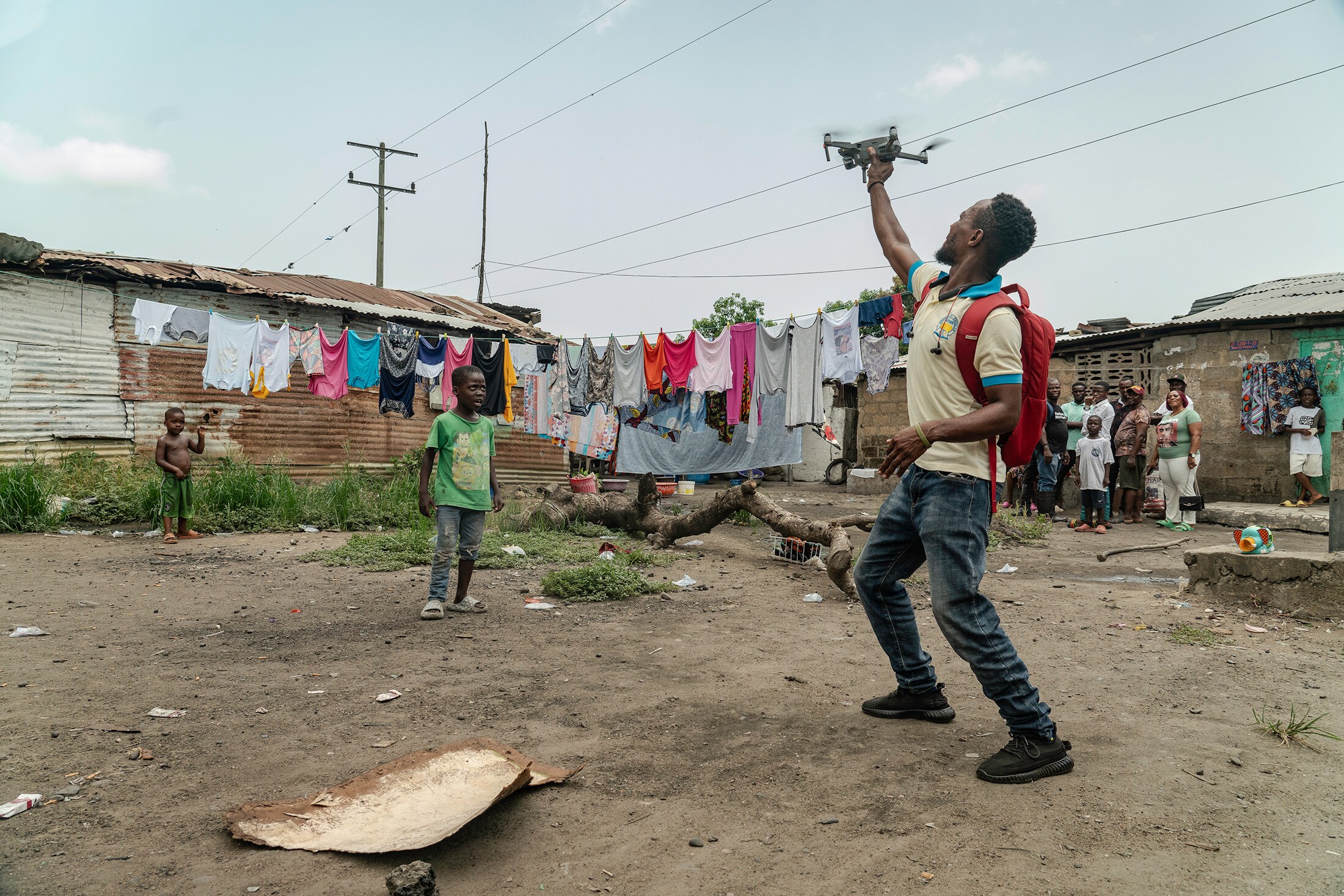
(Bloomberg Businessweek) -- On a cloudy morning in early May, Charles Gamys sends his drone skyward. Once it's about 120 meters (390 feet) in the air, he starts to take photos of the landscape below: rows upon rows of shacks, connected by unpaved alleys and dotted with oil palm trees.
These are no casual snapshots. Gamys, 30, is helping create the first map of Blamo Town, an informal settlement outside Monrovia, Liberia's capital. Blamo Town has been around for almost 70 years and is home to about 20,000 people. On official maps, though, it's depicted with scant detail. On Google Maps, you can't see it at all.
Globally, more than 1 billion people—about 1 in 4 urban dwellers—live in informal settlements such as Blamo Town, defined as slums by the United Nations. Day to day, residents of Monrovia's slums cook, clean, work and gather in tightly packed lean-tos resourcefully built out of mud and scrap metal.
But when natural disasters strike, everything about these settlements becomes a liability, including the lack of mapping. Flooding happens quickly. Structures deteriorate easily. Rescuers don't know where to go. When the city government works on climate-resilience planning, slums are out of sight, out of mind.

“Slums can be more vulnerable to the effects of climate change than other types of neighborhoods,” says Caroline Gevaert, an associate professor at the Faculty of Geo-Information Science and Earth Observation at the University of Twente in the Netherlands. “It is really crucial to do the mapping.”
That's where the Humanitarian OpenStreetMap Team (HOT) comes in. The Washington-based nongovernmental organization joins forces with several other aid groups and residents of slums to put places like Blamo Town on the map, literally. They use drones to create aerial imagery of each settlement and local mappers to interview residents and document every road and structure.

The information can be used in a variety of ways: Detailed maps can serve as the baseline for assessing damage from disasters, for example, while counting the number of structures might inform how much white paint is needed for heat-reducing reflective roofs.
Since its 2010 founding, HOT has participated in slum-mapping projects in more than a dozen cities in 10 countries, including Dar es Salaam in Tanzania and Dhaka in Bangladesh. Similar projects are on the rise globally. The Federation of Liberia Urban Poor Savers (Folups), one of HOT's NGO partners in Monrovia, has mapped 24 of the 100-plus unmapped settlements in and around the city so far this year, and expects to cover 28 more by September.

About 5 miles north of Gamys' drone, Tetee Nyewan, a mapper from Folups knocks on a family's door in an informal settlement known as Duala. She takes note of the house's condition and tells its inhabitants she's there to collect data about the flooding risk in low-lying neighborhoods. Over the next 20 minutes, Nyewan asks them dozens of questions, while three other Duala residents, in training to become mappers themselves, look on.


“The information helps us advocate for our community,” says Nyewan, 34, who grew up nearby. In 2016 her family's hut was a 40-minute walk from the closest beach; that distance has been cut in half as worsening storm surges wash away coastal land.
When she's done with the interview, Nyewan uploads the digital questionnaires to a database that NGOs and the government can access. In Monrovia, Folups and its partners offer local mappers $15 a day for their services—a compelling perk in a country where the per capita gross domestic product was less than $800 in 2022.
“Our goal is to mobilize a critical mass of the urban poor and bring their voices to the table,” says George Gleh, a data coordinator at Folups.

Abijay Williams, 32, who helped map Logan Town, the settlement where she lives, has already seen positive results. After mappers shared tips on how to mitigate local flooding risk, members of the community were able to dredge problematic drainages blocked by trash. During last year's rainy season, floodwaters forced Williams and her family to abandon their home for months.
“Community engagement is fundamental to good adaptation,” says HOT project adviser Pete Masters. “If you don't understand the reality of the community, you're not going to fix the problem.”
More stories like this are available on bloomberg.com
©2024 Bloomberg L.P.
Essential Business Intelligence, Continuous LIVE TV, Sharp Market Insights, Practical Personal Finance Advice and Latest Stories — On NDTV Profit.


